A contemporary journey following the fictional itinerary of King Arthur from England to Rome. Click on the first post in January (see right-hand sidebar) and then follow the posts up to the present.
You might wonder: what is it like to live in a small medieval village? Well, thanks to La Casa Etruria Artist Residency, we had a chance to experience a little bit of what it might be like.
Just ten miles from the official route of the Via Francigena, the small medieval village (borgo medievale) of Latera spills down the side of a volcanic caldera, a flow of stone medieval buildings, churches, and narrow cobblestone streets. The elevation at the top of town is around 1600 feet and probably around 1000 feet at the base of the town. Ladies with shopping bags walk slowly uphill to the café to visit with friends after the daily shopping.
La Casa Etruria, our residency house, is just under the red sign; the front door opens out to a narrow street juuust wide enough for cars to pass through.
The town looks a bit austere at first, but it is filled with friendly people, murals and art, flowers on doorsteps, small historic churches, and a museum of the land and people. I came for a two-week residency, organized by the wonderful Zehava Perez, an artist and creative spirit. As Zehava notes, Latera is “very authentic and natural,” and the area has so much to explore.
My writer’s desk at La Casa Etruria
I came to the residency to write about walking the final segment of the Via Francigena, from Viterbo to Rome, about 115 km. Read about our five-day walk on my blog on WordPress: passionate geography or my Substack (they have the same posts).
If you are an artist or writer, consider applying to La Casa Etruria Artist Residency. Latera is a delightful, unique place to come to with curiosity, a little Italian if possible, and an open heart. You will be well rewarded.
The biggest surprise? The incredible forest (bosco) that surrounds the town. See the next post!
Aerial photo Credit: Frederica Pancrzai, a professional photographer who lives in Latera and owns a photo business, FotoFit, in nearby Aquapendente
[Reader, if you are just joining this journey, click on the “About” tab for context. The chronological posts begin in January 2026.]
May 13, 2026 (Wednesday). Pilgrimage.
Chaucer began his famed Canterbury Tales with the fictional, genial tavern keeper, Harry Bailly, announcing each pilgrim would tell four tales, two on the way to Canterbury and two on the way back. But Chaucer wrote just one tale for each pilgrim. Perhaps Chaucer’s ambitions surpassed “his time or space” to complete the project, but maybe it also speaks to pilgrimages, generally.
The capaciousness of the idea of taking time out of ordinary life to walk in search of transcendence or the divine or forgiveness (by God or of oneself) is probably more than the physical days of a single walk can contain. Some medieval pilgrims never returned home—whether due to death or a new plan. Some pilgrims, such as Margery Kempe in the early 1400s, continued pilgrimages to other destinations, not eager to return home, in her case, to her role as wife, mother, or brewer. But for those who returned, was the fabric of their daily life altered by the pilgrimage? Eventually, even Margery Kempe returned home to care for her ailing husband.
Our pilgrimage is coming to an end, and today we walk to Rome. We take the advice of our guidebook and clamber on a city bus for the first few kilometers of the pedestrian-unfriendly Via Cassia. The bus is Rome-full, and we cram in with about 30 middle school kids on their way to a field trip, all wearing an orange cap. They are laughing, watching TikTok, yelling to each other, making fun of each other. The energy is sky-high, and it’s irresisitible.
We hop off the bus and pick up our trail into a huge natural area called Riserva Naturale dell’Insugherata, an oak tree habitat on the northern edge of Rome. A few kilometers away, the metropolitan area of over 4 million people and 95,000 daily tourists is roaring into the day while we walk in solitude through woods and meadows thick with spring grasses, wildflowers, and bird song.
Around mid-day, we emerge into a city neighborhood, enjoy a cappuccino, then continue on in the intermittent rain. I slip my glasses over my necklace to avoid looking through rain drops. With a billowing orange poncho on, I get snagged by a handrail and swung around. A few minutes later, I discover my glasses are gone. We retrace our steps and there on the pavement near the handrail, miraculously intact, are my glasses! Che fortuna!
Soon we enter Riserva Natural di Monte Mario and encounter a few pellegrini. We chat with Ray, from Japan, and his walking partner Franco, from Italy, as well as three women from Boston. We take photos of each other then resume our own paces through this surprisingly quiet natural area within the city. We ascend Mount Mario and suddenly — Michelangelo’s lofty dome of St. Peter’s! It is a sight we anticipated, but it’s still an exhilarating moment of arrival.
Zigzagging down a steep cobblestone path, we exit the park and walk down Via Angelico toward St. Peter’s, incrementally among more and more people until we are enveloped in the maw and madness of thousands of tourists. Such a day of extremes, and the antithesis of a spiritual arrival.
Being a pelliegrina gives you special status at St. Peter’s: we show our pilgrim’s passport and are ushered to the front of the very, very long line. Prior to arriving, I thought it didn’t seem very “servicio” or “sacrificio” (two of the five virtues on the mountaintop church of Day 4) to jump the line with our pilgrim status (Paul had no problem with it!), but faced with the throng, we gladly accepted the courtesy so as to get our “testimonia,” a certificate of completion of at least 100 km of the Via Francigena.
I had wondered if getting a certificate from the Roman Catholic Church might feel a bit ridiculous. But receiving the testimonia from the volunteers is a surprisingly tender moment, even amidst the throngs. Graduation day is my favorite day of the academic year so it’s no wonder I love receiving the certificate! Our hearts are full—with some travail, we’ve reached our pilgrimage destination and shared a meaningful journey.
Paul and I find a side chapel in the busy and mammoth St. Peter’s to sit and pray, to breath a moment of reflection and gratitude. I find St. Peter’s overbearing: the gilded, Baroque Baldacchino by Bernini—a twisting, bronze canopy over the altar—the sculptures of saints and popes, all a counter-reformation swirl of more, and more. Michelangelo’s Pieta provides a counterpoint of quiet naturalism and reverence.
We prepare to leave this complex space—a vortex of mass tourism and spirituality—and notice that people are congregated just before the massive exit doors. A heavy rain is pummeling down, so Paul and I help each other back into our ponchos, making sure to bury our certificates in our packs. With that, our pilgrimage ends, at one level. We walk out into the downpour, open to what might come next.
Oh glorious new day and the regeneration of both sleep and springtime! Paul worked on my back and we have new energy for the day and walk ahead.
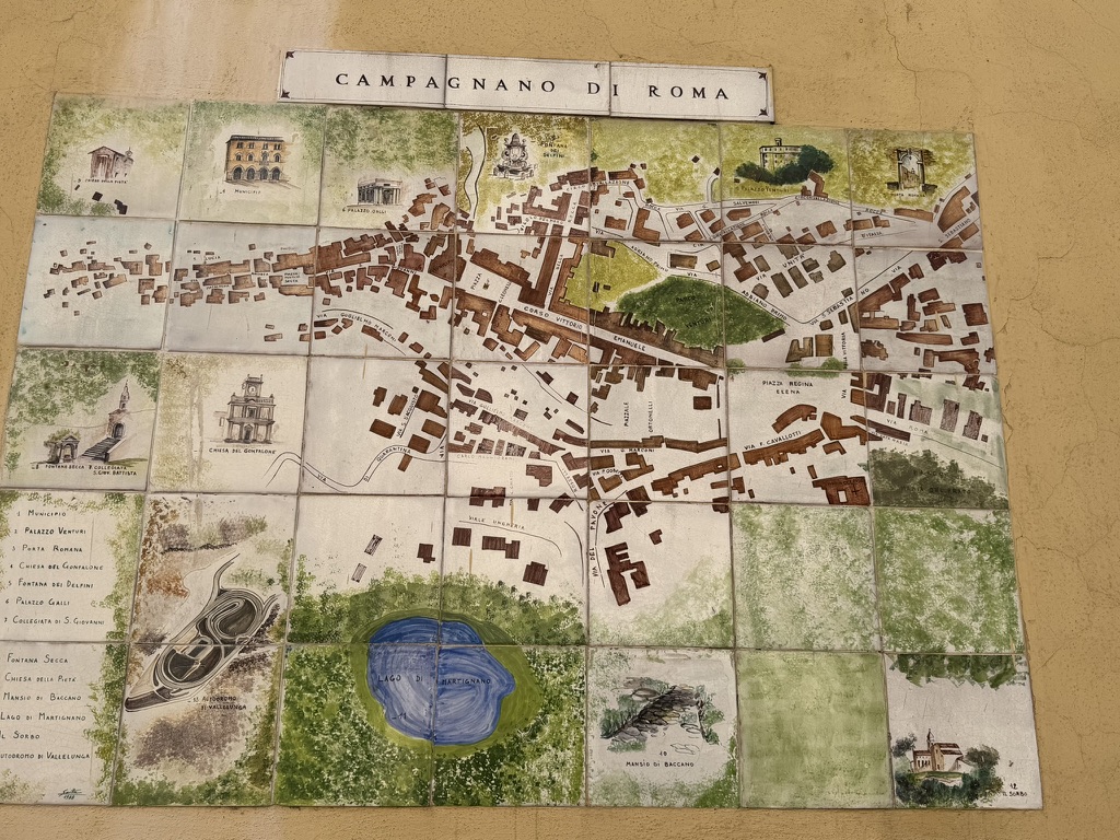
Notice that the map of Campagnano di Rome includes the surrounding bosco, forest. A surprising aspect of being in these stone medieval towns is that they are in conversation, spatially, with the surrounding forests in a way that is incredibly beautiful, affording expansive views and a sudden transition from cityscape to landscape. And it is springtime here in Italy and so so green . . .
We read on the Via Francigena app that the trail for the second portion of today’s walk, from the town of Formello, about half-way through, to La Storta, our destination, has been washed out due to a landslide from the recent rains. We set off for Formello for the first half of the walk; rather than walk the busy road that is offered for the second part of today’s walk we plan to . . . take another bus! Good for the recovering back as well.
After walking up steep country roads into the Parco Vero in the Sorbo Valley, we come to the hilltop Santuario del Sorbo, a former convent with a wide vista of the surrounding forest and countryside. On the alter is perched an 11th c icon of the Madonna and child, serene and placid over these many centuries. In the apse, is a fresco of the ascension of Mary (my Catholic upbringing comes in handy for interpreting the various scenes depicted in medieval art). What captures my attention is the earthly city (presumably Jerusalem?) that she is leaving behind. Notice the close interchange between town and landscape, a feature that we are experiencing today.
Outside the church, we eat a cheese sandwich and take in the glorious view on this sunny but temperate and slightly breezy day. Oh to be walking the Via Francigena in spring!
Before we leave this mountaintop sanctuary, we notice a sign: Eccomi, which translates as “Here I am.” Exactly. We feel present and touched by the quiet spirituality of the various churches along the way as well as of the landscape and friendly welcomes we have received at the various inns and trattorias. As we begin to walk back down the steep driveway, we notice a series of signs declaring five virtues: gioia, bonito, austeria, servicio, sacrificio (joy, goodness, austerity, service, sacrifice). We reframe them within our sensibilities to joy, kindness, simplicity, service, and . . . consideration of the needs of others?
We cover a few more kilometers in the Sorbo Valley and come into the town of Formello. Here we say hello to a group of pelligrini that we saw this morning. They are a high-spirited group from Poland and are camping along the way. We eye their heavy backpacks and are glad to be waking inn to inn.
We drink a coke with a few cubes of ice (which is hard to come by) then criss-cross the town trying to find the bus stop to take us to La Storta. The Polish pelligrini laugh in friendly camaraderie as we pass by them four times (!!) due to our phone map’s arrow getting confused among the medieval walls.
At last we get on a bus going somewhere that turns out not to be where we need to go! The driver kindly stops to let us off and we just have a good laugh at the ridiculous last hour of aimless wandering. Finally, we resort to modern technology and summon an Uber to take us from a bus stop somewhere on the side of the road outside Formello to La Storta, a quick 6 mile ride.
After days of solitude and the open spaces of farms and forests, we arrive at the busy, commercial strip of the Via Cassia which our guidebook describes as “charmless.” Tomorrow, the last leg of the journey will bring us into Rome; it looms large in our imagination and we wonder what this culmination of our Via Francigena walk will mean to us.
Hubris. We woke from a night’s rest after our long, rainy walk yesterday stiff and achey. We both exercise daily, but we did little or nothing to prepare for this walk. And this morning–we feel it. Oooff! Being generally fit does not prepare you for walking 15 to 18 miles a day carrying a light backpack. Yes, hubris.
We stretch and feel better. After checking the All Trails app, we see comments from previous hikers that the first 10 km is along a busy, trafficy road with no shoulder. They warn that it is dangerous and a bad route. Our alternative is to ADD a 3.2 km detour that we already walked by mistake yesterday (and back).
We consider the “purity” of our walk–does it “count” if we don’t walk every kilometer? With a certain liberation, we opt to take a local bus through the first dangerous kilometers. We shoulder our backpacks and groan but are relieved that it will be a shorter walk day.
This option gives us time to explore the medieval hill town of Sutri, have a cappuccino in the town square, notice the “Arthurian” town logo, and visit the Roman amphitheater carved out of rock (rather than built of concrete).
Can you see my relief at being on the bus? The narrow, dangerous road road did justify our decision–when that bus passes the oncoming car the only option would be a leap into the bushes–but the relief is mostly for choosing joy over pain, letting go of an external “should.”
On we go past large fields, olive groves, white sheep and white cattle. My back hurts and my toes are blistered. We climb in elevation to Monte Gelato where there is a refreshing stream and cascata (waterfall). I speculate that Italian words starting with “gel-” must mean cold or icy: gelato (ice cream), ghiaccio (ice) and here, a mountain with icy-cool cascades.
That last kilometers to our destination are slow-going. I have to stop every half hour to take off my backpack and stretch. I wonder, for the first time, if I’ll be able to keep up the daily walk. At last, the bell tower of Campagnano di Rome rises from the landscape like a vision of Oz. I think of the phrase from Malory’s Roman War episode in which the Roman ambassadors reach Sandwich and “were never so blithe” [happy] at arriving at their destination. It’s been a tough day of walking and we have a very steep ascent up into the medieval hill town, but I am feeling “blithe” to reach the day’s destination.
I wonder if the “testimonia” that we will receive when we finish the pilgrimage is like a certificate from Oz, simply confirming the strengths we already have? What is the affirmation we are seeking?
Before we began our Via Francigena pilgrimage, we reflected on our intentions and aspirations. Rome, as the Catholic center of the world, does not hold a religious force for either of us. I grew up Catholic and was once married in the Catholic Church, but I journey now, as does Paul, with the Lutheran community and with Buddhist teachings.
Medieval pilgrims were drawn to Rome as the center of their faith. Jerusalem was often unsafe or impossible to reach for European Christians in the Middle Ages, so Rome became a kind of stand-in for the Holy Land: it was the site of the martyrdom of St. Peter and of St. Paul and had become the holy city of Christianity.
For us, our intentions are not relief from purgatory, absolution of sins, or earning credits toward salvation (though perhaps we need them!). Influenced by Buddhism and its emphasis on mindfulness, our intentions are to be present — to walking, to the landscapes, to spirit within us and those we meet, and to each other. With gratitude for being able-bodied, we are animated by this ancient route, trod by generations of traders, soldiers, emissaries, and pilgrims before us. Andiamo!
We start out from Vetralla under overcast skies. Along the way, we stop into any church with an open door and are particularly drawn to images and statues of Mary (my Catholic upbringing!) or to ones of Mary as Mother with child. Paul has a new grandson so babies on our on minds. A light drizzle comes and goes, so the 2 Euro poncho becomes essential.
We are soon out of the town area and pick up a trail into the thickly wooded oak forest of Bosco Montefogliano Park where we hike for an hour or so. With the spring rains, it is incredibly lush with every possible shade of spring green, both in the tall forest canopy, in the verdant undergrowth, in the tangle of wildflowers, and in the open meadows. We see two pelligrini this morning, heading out of town, and two more coming from the direction of Rome; other than that, we have this incredible bosco on this Sunday morning to ourselves, awash in birdsong.
After the forest, we travel through landscapes shaped by human culture: acres and acres of hazelnuts (we are in the land of Nutella, and Italy, after Turkey, is a major producer. Coming from Oregon, I chauvinistically thought the Willamette Valley was the hazelnut capital of the world, but I learn that it is the hazelnut capital of the U.S. and only a small part of world production.) We pass by an iconic country villa driveway, lined with Italian cedars and umbrella pines, and, in the town of Capranica, see that a wedding happened earlier in the day.
In the afternoon, I become aware that I have thrown out a rib or pulled a muscle (by frequently twisting around to get my camera out of my backpack). By now, a deluge has started and we two pilgrims scurry through a dark woods in pouring rain, mimicking Tolkien’s hobbits hurrying through the foreboding Mirkwood Forest. The rain is pummeling down in earnest now. Ponchos on, head down, about 5 miles to go til we get to Sutri.
At last, we see the clock tower of Sutri ahead and experience the relief pilgrims must have felt in coming out of the forest and into a town. But we are so downward focused due to the rain that we walk right by our inn and trek an additional 2 miles past and then 2 miles back. We arrive cold and stiff.
Still, the rains enforced our intention of being present–we could do nothing more than walk, step by step.
[We can] learn to live in an awakened way, living deeply every moment of our life, treating those with who are close to us with gentleness and respect . . . Living in the present moment we are able to be in touch with life’s wonderful, refreshing, and life-giving phenomena, which allow us to heal the wounds in ourselves. Every day we become more wonderful, fresh, and healthy.
— from Thich Nhat Hahn, “Deep Seeing,” The Pocket Thich Nhat Hanh
The wisdom of the Buddhist monk, Thich Nhat Hahn, is reflected in this sign along the muddy forest trail:
Sign in photo: Ambulo Ergo Sum. Translation from the Latin: I walk, therefore I am.
May 9, 2026 (Saturday). We leave Viterbo under sunny skies and with high spirits!
We start on the Viccolo dei Pelligrini, the traditional route out of Viterbo to Rome, and are outside the city walls in just a short time. We are soon walking along the mysterious Etruscan cave-road, then past fields edged with wildflowers and an abundance of poppies.
After about an hour and a half of walking, we detour to the Terme Tuscia, adding a few kilometers to the day’s total. The Lazio region is volcanic so there are many hot springs. Even though we haven’t “earned” a rest yet, we have to sample the local soaking culture!
Along the way, we pass farm fields, trek uphill past olive orchards, and are barked at by the large, white Maremmano dogs, traditional in this area for tending flocks of sheep. The general area we are walking in is known as Tuscia Viterbese, rich in Etruscan (pre-Roman) history. So far, we have seen just three other “pelligrini” (pilgrims) and have spent most of the day in rural areas without seeing another soul.
In the late afternoon, we visit Santa Maria di Foro Cassio, an 11th century church along the roadside, then walk up hill to the village of Vetralla, in the foothills of Monte Fogliano.
Map from ForWalk website
Our pilgrim passports have been stamped in Viterbo, Terme Etrusia, and at Santa Maria di Foro Cassio, satisfyingly validating our sense of accomplishment at the end of the day. Ever a gold-star sticker kid!
The presence and imagery of pilgrims, “pelligrini” in Italian, along the towns of the Via Francigena is centuries old, as the reproductions of medieval pilgrims, above, represent.
Viterbo has a sizable medieval quarter, an astonishing and beguiling portal to another era. The medieval “profferlo,” above right, is a beautiful architectural structure unique to the Viterbo area, a ground-level commercial space with a curved stairway up to the living quarters.
Two small packing “cubes” will stuff into each of our daypacks, all that we are carrying for the next week. Two shirts, one pair of pants, one skirt, a light sweater, and a “Houdini” (a compressible wind- breaker). We are leaving our suitcases with the hotel.
The greeting to fellow pelligrini is either “buon viaggio” (have a good journey, in Italian) or “buen camino” (have a good walk, in Spanish, adopted from the more famous walk to Santiago de Compostela in Spain, known as the Camino de Santiago or Way of St. James).
Tomorrow morning, we will start our walk under the lace-like arches of the Palazzo dei Papi, the complex where 13th century popes left Rome for a safer situation and cooler climate. For us, a cool May offers a forecast of 60 to 70-degree temperatures mixed with rain. We buy Paul a 2 euro plastic poncho, just in case. We’ve got our pelligrini “passports” to collect stamped imprints along the way that will validate that we made the 112km journey to Rome. Will we make it??
Guidebook (check), All Trails app (check), phones (check), water (check), ponchos (check!)–backpacks on! Andiamo a Roma.
Friends–I’m interrupting this narrative journey to walk a part of the Via Francigena, from the amazing medieval city of Viterbo (the largest intact medieval quarter in Italy) to Rome! When done, I’ll post a daily capture of the journey.
[Reader, if you are just joining this journey, click on the “About” tab for context. The chronological posts begin in January 2026.]
Ryght so [Arthur] sought, and his knyghtes, towarde Sandewyche where he founde before hym many galyard [sturdy] knyghtes—for there were the moste part of all the Rounde Table redy on tho bankes for to sayle whan the Kynge lyked.
Despite its historic and literary pedigree, I’m glad to leave the crammed city of Canterbury behind. I trundle my rolling suitcase past the busy tourists’ shops to the bus station, waiting in the glorious late-afternoon sun for the bus to Sandwich. At last, as winter-weary English folk have sung for centuries: Summer is icumen in [Summer is a coming in], possibly the oldest known English song (13th c).
No one seems to know when the bus is due, so I perch atop my suitcase and wait alongside the elderly women with their shopping bags and students in school uniforms heading home. The “queue” is long, and I’m nervous about not getting on the bus, but we all manage to squeeze on. After many local stops at country roads and corners in small towns, the bus pulls in at last to Sandwich.
The bus driver directs me to the New Inn, a pub where I have booked a room up on the second floor, one of the few accommodations in this small town. The entry door to the pub is stuck and when it gives way to my insistent pressure, I burst into a small-town pub filled with men enjoying a pint at the end of the workday. All heads turn my way to assess this unlikely addition to the scene.
My entry to the New Inn pub is a gender-inflected moment: pubs are still predominantly male spaces. I step up to the bar and, while waiting to get my key, easily chat with three young men and an older gent, asking for directions to the river. Their directions are hopelessly confusing, but it’s fun to have an excuse to be in a space that I would not normally feel able to enter on my own.
Despite the convoluted directions, I find my way to the peaceful River Stour and take an evening walk on this long, northern-summer’s evening.. In contrast to the intensity of York, London, and Canterbury, Sandwich is a quiet town and the tree-lined banks afford a solitary amble. The July sun is low in the sky and a brisk breeze with a slight tang of salt and sea disturbs the surface of the water.
The placid, curving river is lined with rushes and small pleasure boats; pathways, marshes, and small woodlands form part of the river’s geography.
In the town, there are quaint half-timbered, medieval houses and shops that lean over narrow cobble streets.
A surgeon’s office, I kid you not, is located on Butchery Lane.
Of course, Sandwich is not only an idealized town, but part of the modern British landscape. The town has an authentic ‘self-ness,”with practical shops that sell shoes and bread boxes, flowers and groceries. In the distance, I can see the massive cooling towers of a nuclear plant, but the juxtaposition of modern energy production doesn’t perturb the bucolic ethos and textual geography.1 Walking alongside the river, it is easy to feel immersed in a landscape with a far past, textual and geographic. I can still enter Malory’s text.
The nuclear power plant has since been dismantled and the cooling towers removed, creating an even greater scope for the imagination about a medieval text! ↩︎
[Reader, if you are just joining this journey, click on the “About” tab for context. The chronological posts begin in January 2026.]
Source: Antony McCallum, on Wikipedia
Canterbury is in the general direction of Sandwich, and I couldn’t resist the minor detour. As a professor of medieval literature, I’ve often taught Chaucer’s Canterbury Tales with its inimitable characters—the pious, the bawdy, and the loathsome. Who doesn’t love the Wife of Bath and her humorous tirade about her five husbands?
The justly famous Cathedral at Canterbury, rich in ecclesiastical history, is the destination of Chaucer’s motley pilgrims in The Canterbury Tales. The opening of the Canterbury Tales form one of the most amazing poetic single sentences in English literature, ending with these lines:
And specially, from every shires end
Of Englonde, to Canterbury they wende
The hooly [holy] blissful martyr for to seke [seek]
That hem hath holpen [who had helped them] whan that they were seke [sick]
As the train “wends” its way from London to Canterbury, I review essays I am carrying by Arthurian scholars Drs. Peter Field, Thomas Crofts, Edward Donald Kennedy, Kevin Whetter, Ralph Norris, Masako Tagaki, and Takako Kato—wonderful medievalists who research the manuscript and printed text versions of Malory’s Le Morte Darthur. We are on panels together at the Congress next week about the editorial and interpretive questions that arise as a result of the two versions of Malory’s Roman War episode.
This English book, Le Morte Darthur, has traveled to the quiet, lamp-lit offices of scholars in Europe, Canada, Australia, Japan, and the far west coast of America: to my home in Portland, Oregon. My wheelie suitcase is crammed with professional clothes and my briefcase is heavy with a laptop and work papers for the upcoming International Arthurian Congress in Rennes, France.
As I near Canterbury, the Kent countryside is dotted with woodlands and large oak trees that spread their broad canopies over the landscape.
~ ~ ~
Canterbury, like many English cities with cathedrals or colleges, is packed with tourists and lively groups of youngsters studying English for the summer. It makes for an intense crowd experience and shapes the space of these cities such that, at a certain level, they feel almost indistinguishable.
I stash my heavy bags at a tourist shop, then wander through the hushed twilight of the Cathedral interior, craning my neck to see the exquisite fan vaulting. English pilgrims came seeking healing from St. Thomas a’ Becket, once archbishop of Canterbury.
It is also the home cathedral of the 9th century Archbishop Siguric who was the first to record the itinerary of what is now known as the Via Francigena, the route between England and Rome that I am roughly following. For more on Siguric, see this post.
As I amble around the town, I happen to see a nondescript sign on a nondescript building: it reads: Watling Street.
Hey!
Do you recall Arthur’s injunction to the fleeing Roman ambassadors?
loke ye go by Watlynge Strete and no way [else]
Come to find out — Watling Street was one of the first and most important Roman roads in Britain! It once stretched across the width of the island running west from Dover through Canterbury, London, and on to Wroxeter in the northwest.
A map of Watling Street overlaid on the 1911 Encyclopædia Britannica map of Roman Britain. Annotated to show Winchester, London, and Canterbury. Source: Wikipedia
On the map above, Winchester, London, and Canterbury are circled in orange. The red line marks the length of Watling Street (we don’t know what the Romans called it; the name derives from Anglo-Saxon). From London it would be a straight shot to Sandwich, near the Roman fort at Richborough (it was a Roman road, after all).
No wonder the Roman ambassadors in Le Morte Darthur “so blithe [relieved] were they never” upon arriving at Sandwich! It is a formidable journey to cover from Winchester to London and then on to Sandwich in just seven days (almost 150 miles). Once they arrived, the ambassadors breathed a shaky sigh of relief and boarded their ships, leaving Britain behind.
To get from London to Canterbury to Sandwich to the ferry crossing to France without a car is not a simple journey. Train to Canterbury, local bus to Sandwich where I’ll spend the night. Train to Dover, ferry to Calais in France, rental car to Rennes. I realize I don’t have a map . . . just a copy of Le Morte Darthur with its Roman War itinerary as a guide.
For Further Reading:
John Higgs, Watling Street: Travels Through Britain’s Ever-Present Past (2017)
Former English professor at Marylhurst University for 16 years, then Concordia University. I taught writing, medieval literature, humanities, maps and literature, and history of the book. After five years as a Dean of arts and humanities at Linn-Benton Community College, I am now a writer and an instructor at Willamette University – Pacific Northwest College of Art.